From paper charts and compasses to chartplotters, radar, AIS, and VHF radios, every navigation tool has its place. Some help you find your course, some help you avoid trouble, and some give you the backup you’ll be glad to have when conditions get sloppy.

Reliable navigation comes from layers, not shortcuts. A boater who understands the strengths and limits of each tool is in a much better position to make smart calls when traffic gets heavy, weather closes in, or a primary system goes down.

Shop Popular Marine Navigation Gear

Why Marine Navigation Still Requires Multiple Tools

Modern marine electronics are excellent, but no single tool covers every situation on the water. Good navigation still depends on redundancy, because losing one source of information should never leave you guessing about your position, your surroundings, or your next safe move.

All this matters because electronics do fail, and usually not on a calm afternoon when everything is easy. Throw in power loss, bad weather, screen glare, damaged transducers, lost GPS signal, or simple user error, and a reliable setup will quickly turn into a partial picture at best.

Traditional Marine Navigation Tools (Still Essential)

Traditional navigation tools still earn their keep because they do not rely on a touchscreen, a clean power supply, or perfect signal. When conditions get messy, these are often the tools that help boaters slow down, cross-check what they know, and keep making sound decisions.

Magnetic Compass

A magnetic compass gives you a steady heading reference without relying on power, software, or satellite signal, which is exactly why it still belongs at the helm. When GPS drops out or electronics fail, a properly installed marine compass can still help you stay oriented and hold a safe course. To use it properly, boaters need to understand variation, the difference between true north and magnetic north, and deviation, the error created by the boat’s own electronics, wiring, and metal.

Paper Nautical Charts

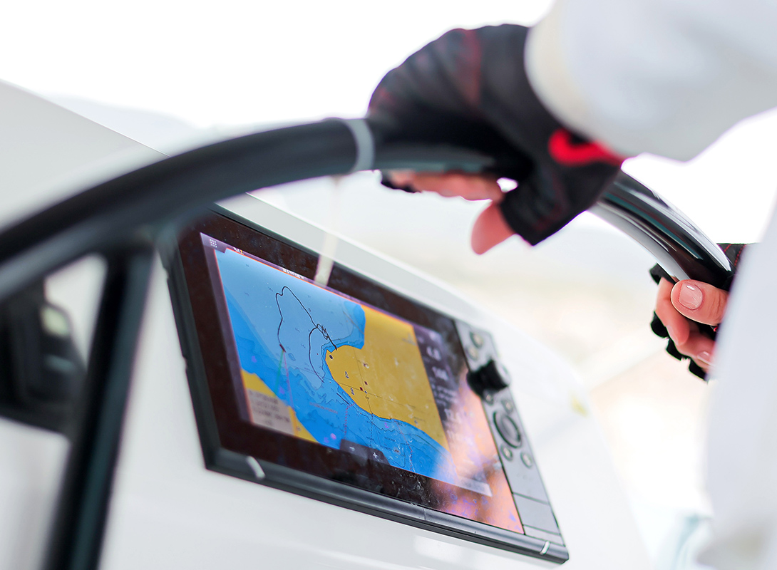
Paper charts still matter because they show the full waterway in one view, including depths, contours, hazards, channels, and aids to navigation, instead of limiting you to whatever happens to be on a screen. They also help boaters read depth soundings, understand chart symbols, and build a better sense of how the water, shoreline, and markers fit together. When electronics fail or route planning needs a wider view, paper charts remain one of the best backup tools onboard.

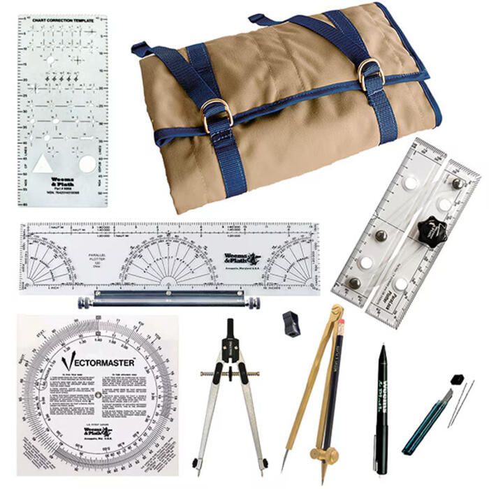
Parallel Rulers & Dividers

Parallel rulers and dividers are old-school plotting tools, but they still do real work when you need to plot a course, check distance, or make sense of where the boat ought to be. They come into play for the hands-on side of navigation, including dead reckoning, where you estimate your position from a known point using heading, speed, and time underway. Even with good electronics onboard, knowing how to use them means you’re not helpless the second the fancy stuff quits.

Binoculars with Bearing Compass

A good pair of marine binoculars is not a luxury item for the boat. Rather, it’s an essential part of a proper navigation and safety setup.

They let you read the water farther out, sort out traffic sooner, and identify buoys, markers, and shore features before you are making decisions late and under pressure. Add a bearing compass, and they become even more useful offshore, where distance, haze, and limited reference points can make the whole horizon lie to you.

Electronic Marine Navigation Systems

Modern marine electronics can do a lot, and good gear earns its keep in a hurry once visibility drops, traffic builds, or the water gets unfamiliar. But these systems work best when you understand the job each one is doing, because no single screen tells you everything you need to know. The trick is building a setup that gives you a clear picture of the boat, the water, and everything around you before small problems get the chance to grow teeth.

GPS vs Chartplotters

GPS and chartplotters get lumped together all the time, but they do different jobs. A GPS gives you the raw position data, while a chartplotter builds that into a full navigation display with charts, routes, waypoints, and a clearer working picture at the helm. This matters because the right choice depends on whether you want basic information or a more complete, high-function setup that makes navigation easier, cleaner, and more intuitive day in and day out.

Tool What It Does What You See at the Helm Best Fit Main Advantages Main Limitations
Standalone GPS Provides position, speed, course, and waypoint data Basic location and navigation data, usually on a simpler display Boaters who want straightforward navigation data, a backup unit, or a simpler setup on a smaller boat Simple to use, dependable, often more affordable, useful as a backup Less visual detail, limited route planning, fewer integration options
Chartplotter / MFD Combines GPS data with electronic charts, routes, waypoints, and often other onboard systems A full navigation picture with charts, track lines, route planning, and system data in one place Boaters who want a more capable primary navigation setup for regular cruising, fishing, coastal runs, or offshore use Easier route planning, better situational awareness, more intuitive at the helm, often integrates with radar, sonar, AIS, and autopilot Higher cost, more complexity, and more reliance on electronics overall

Marine Radar Systems

Radar matters when visibility goes bad and guesswork starts getting expensive. It helps you pick targets your eyes cannot sort out in fog, rain, darkness, or crowded water, which is why plenty of serious boaters see it as working gear, not a luxury. Dome radar is enough for a lot of smaller boats, but open-array systems come into their own on larger boats where extra range and sharper target detail are worth having.

AIS (Automatic Identification System)

AIS helps you keep tabs on nearby AIS-equipped vessels by showing who they are, where they’re headed, and how fast they’re moving, which is a lot safer than trying to eyeball it. That matters most in commercial traffic, low visibility, and busy water, where a bad read can close the gap faster than you’d like. Recreational boats are not always required to carry AIS, but plenty of serious boaters run it anyway because having more time and more information is rarely a bad bargain on the water.

Depth Sounders & Sonar

Depth sounders and sonar both tell you something about what is under the boat, but they are not always doing the same job. A basic depth sounder is there to keep you honest about the water below the hull, while more advanced sonar is built to show bottom detail, structure, and, in many setups, fish. The transducer matters just as much as the screen, so the right setup depends on whether your priority is safe navigation, better fishing intel, or a system that can handle both.

Autopilot Systems

Autopilot is not there to replace boat handling or common sense, but it does take a lot of the grind out of steering on longer runs. When tied into a chartplotter, it can follow a set course or route with far less constant correction, which makes it especially useful for coastal cruising, offshore passages, and short-handed crews. Used properly, autopilot is less about making things easy than about cutting fatigue and freeing up attention for everything else that still needs watching.

Communication as a Navigation Tool

Knowing your position is only part of the job. You also need to hear the traffic around you, get information when conditions shift, and have a reliable way to call when the water stops playing nice.

VHF Marine Radios

A VHF radio is one of the most important tools at the helm because it gives you a direct line to other boaters, marinas, bridges, and the Coast Guard when it matters. Channel 16 is the main hailing and distress channel, while DSC gives you a faster, more precise way to send a distress alert. Handheld VHF radios and fixed-mount radios both have their place, but the right choice comes down to how much range, power, and reliability you want onboard.

VHF Antennas

A VHF radio is only as good as the antenna tied to it, because range depends heavily on antenna quality, placement, and height above the water. In plain terms, the higher the antenna, the farther the radio can usually reach, which is why a properly matched antenna setup matters just as much as the radio itself.

Navigation Lights & COLREGS Compliance

Navigation lights are not there to dress up the boat after dark. They are part of the language boats use to avoid confusion, bad decisions, and close calls when visibility drops.

That means the lights have to be right, and the rules behind them cannot be guesswork.

Required configurations depend on the boat and the situation, and it pays to know where inland rules apply, where international rules kick in, and how proper navigation lights keep you from sending the wrong signal.

Advanced Navigation Technology (For Offshore & Cruising)

Once you get into offshore runs and longer cruising miles, the gear list starts getting more serious for a reason. Tools like thermal cameras, forward-looking sonar, and satellite communication are built for the kind of water where a small problem can suddenly get expensive, exhausting, or dangerous.

That does not make them mandatory for every boat, but they can add real value when the miles stack up and the margin for error gets thinner. And like everything else in navigation, the point is not to pile on gadgets for the sake of it, but to build a setup with enough range, backup, and overlap to keep working when conditions turn on you.

Technology Makes Sense When…
Thermal cameras You run at night, deal with poor visibility, or spend enough time offshore to know that seeing trouble late gets expensive fast
Forward-looking sonar You work shallow, poorly charted, or unfamiliar water where finding the problem after the keel does not count as a good system
Satellite communication You run beyond reliable cell coverage and want a solid line out when things go sideways
Backup handheld GPS You want a no-nonsense fallback if the main unit quits
Redundant power / backup displays Your navigation setup leans hard on electronics and you do not want one failure taking half the picture with it

Navigation Tool Recommendations by Boater Type

The right navigation setup depends on how and where you run the boat, not just how much gear you can bolt to the helm. A skiff on inland water, a coastal cruiser, and an offshore fishing boat do not ask for the same tools, and treating them like they do is how people overspend in the wrong places or cut corners where it hurts.

Boater Type Typical Use Core Navigation Tools Nice-to-Have Upgrades Main Priority
Weekend boater Day trips, familiar local water, short marina runs Compass, paper chart backup, VHF radio, chartplotter or GPS Handheld VHF, basic depth sounder Simple, dependable navigation
Freshwater angler Lakes, rivers, inshore structure, fishing-focused runs Chartplotter/fishfinder combo, depth sounder, VHF where relevant, compass Advanced sonar, upgraded transducer, handheld GPS Finding structure and staying aware of depth
Offshore angler Offshore runs, open water, longer distances Chartplotter, radar, AIS, VHF, compass, paper chart backup Autopilot, satellite communication, thermal camera Redundancy and situational awareness offshore
Coastal cruiser Coastal passages, changing weather, traffic, harbors Chartplotter, VHF, radar, compass, paper charts AIS, autopilot, backup GPS Safer route planning and traffic awareness
Sailboat cruiser Coastal or offshore passage-making, longer time underway Compass, paper charts, chartplotter, VHF, AIS Radar, autopilot, satellite communication Layered navigation and backup systems

Building a Redundant Navigation Setup

A proper navigation setup has layers to it, because one screen, one signal, or one power source is not much comfort once something quits. The primary system handles most of the work, but it should never be the only thing keeping you from running half-blind when conditions turn or gear starts dropping out.

The backup system is there to keep you in the game when the main setup goes down or starts feeding you only part of the picture. That can mean a second GPS source, paper charts, a magnetic compass, a handheld VHF, or any other gear that gives you a workable read on position, direction, and what is happening around you.

The emergency system is the last layer, and it needs to be simple, dependable, and ready when everything else has gone sideways. At that point, the goal is not smooth navigation or convenience, but staying oriented, calling for help if needed, and keeping the boat and everyone on it out of deeper trouble.

Out on the water, the same questions come up for a reason, and most of them matter a lot more when the weather turns, traffic builds, or the easy answer stops being enough.

Frequently Asked Questions

What navigation equipment is legally required on a boat?

The exact requirements depend on the boat, where it is operated, and the conditions, but smart boaters know the law is only the starting point and not the full gear list.

Do I need radar for coastal boating?

Not always, but it starts making a lot more sense once you deal with fog, night running, heavy traffic, or water where the view from the helm is not telling you enough.

What’s the difference between GPS and chartplotter?

A GPS gives you position data, while a chartplotter turns that information into a full navigation picture with charts, routes, and waypoints at the helm.

Is AIS required for recreational boats?

Usually not, but plenty of serious boaters still carry it because knowing who is around you and what they are doing beats guessing every time.

Can I rely on my phone for marine navigation?

A phone can help, but it is not a full navigation system and should never be the only thing you trust once you are off the dock.

What’s the best navigation setup for the Great Lakes?

A solid Great Lakes setup usually means a chartplotter, VHF, compass, depth sounder, and paper backup, with radar or AIS making even more sense once weather, traffic, or longer runs enter the picture.

What navigation tools do I need for offshore fishing in Florida?

For offshore Florida runs, the short list usually starts with a chartplotter, VHF, radar, depth sounder or sonar, compass, and paper backup, with AIS and autopilot often earning their keep fast.

What is the most important navigation tool onboard?

No single tool carries the whole load, but the most important setup is one with enough overlap and backup that you are not left half-blind when one piece quits.