

Garmin
Garmin GPSMAP 9017 Chartplotter with Worldwide Basemap - 17" - 010-03177-00
Item: #2254548 | Part Number: 010-03177-00$6,699.99

Description
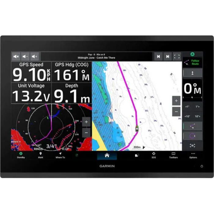
The Garmin GPSMAP 9017 Chartplotter delivers uncompromising navigation performance with a stunning 17" 4K IPS touchscreen display and lightning-fast processing. Designed for serious captains, it offers seamless glass helm integration, advanced sailing features, and robust network connectivity for complete control on the water.
Garmin GPSMAP 9017 Chartplotter with Worldwide Basemap - 17" - 010-03177-00 Item # 2254548
Description
GPSMAP 9000 series are the integrated touchscreen chartplotter designed for captains who demand the best. Enjoy edge-to-edge clarity with up to 4K resolution on a glass helm with premium design and materials. Plot your paradise faster than ever with processing power that's up to 7 times faster than previous generations, 5GHz Wi-Fi connectivity for ActiveCaptain app updates and the Garmin BlueNet network.
Features:
- Premium 4K IPS sunlight-readable touchscreen display available on the 13" and 17" models; 10" model features full HD display
- Glass helm with edge-to-edge design for seamless and modern look
- Processing power is up to 7 times faster than previous generations for superior performance, plus get faster wireless ActiveCaptain app transfer speeds with 5GHz Wi-Fi connectivity
- Enjoy premium sailing features, such as sailing polars, plus see laylines, race start line guidance and more with Garmin SailAssist features
- Build extensive networks with reliable connectivity and gigabyte speeds on the Garmin BlueNet network
- Enjoy high-quality entertainment with video integration capabilities with HDCP distribution
- Uses the NMEA 2000 and NMEA 0183 networks to connect to your compatible autopilots, sensors and more; compatible with existing marine ecosystems
- Take command of monitoring, control and automation systems with support for the EmpirBus system and other third-party solutions via OneHelm integrated digital switching
- Keep tabs on engine performance with extensive engine integration, including SAE J1939 connectivity and a wide range of support for outboard engine manufacturers
- Support for Garmin Navionics+ charts with Auto Guidance+ technology (for planning purposes only and does not replace safe navigation operations) and Garmin Navionics Vision+ charts with premium features such as high-resolution relief shading
- Connect your compatible Garmin devices and more with integrated Bluetooth and ANT technologies; use spoken commands to control the chartplotter with your compatible headset or Garmin smartwatch
- Built for harsh marine conditions with an IPX7 water-resistance rating
Specifications:
- Dimensions (L x W x D): 16.80" x 11.23" x 3.60" (42.7 x 28.5 x 9.2 cm)
- Weight: 13.0 lbs (5.90 kg)
- Water Rating: IPX7
- Touchscreen: Yes
- Display Type: 4K, IPS, mini LED (local dimming) backlight
- Display Size (L x W, Diagonal): 15.04" x 8.50", 17.25" (38.2 x 21.5 cm, 43.8 cm)
- Display Resolution: 3840 x 2160 pixels
- Mounting Options: Flat or flush
- Input: Touchscreen
- Polarized Lens Viewability: Yes
- Waypoint Capacity: 5,000
- Navigation Routes: 100
- Receiver Frequency: 10 Hz
- Power Input: 10 - 32V DC
- Typical Current Draw: 4.3A at 12V
- Maximum Current Draw: 1.9A at 12V
- Maximum Power Usage: 52W at 10V
- NMEA 2000 Ports: 1
- NMEA 0183 Ports (Rx/Tx): 1 / 1
- Video Input Ports: 1 BNC Composite, 1 HDMI (HDCP)
- Video Output Ports: 1 HDMI
- Garmin BlueNet Ports: 2
- USB Ports: 1 USB-C
- Wi-Fi Bands: 2.4 GHz & 5 GHz
Compatibility:
- Supports BlueChart g3, g3 Vision, LakeVu g3, and LakeVu g3 Ultra mapping
- Compatible with Garmin Navionics+ and Navionics Vision+ charts
- Works with GCV black box sonar and Fusion-Link compatible radios
- Integrates with ActiveCaptain, Smart Mode, GRID, and OneHelm systems
Inlcuded:
- GPSMAP 9017 premium chartplotter
- Power cable
- 2 m (6.6') Backbone/drop cable or T-connector for the NMEA 2000 network
- Flush mount kit
- Protective cover
- Trim piece snap covers
- Documentation