

Garmin
Garmin ECHOMAP UHD2 73sv Chartplotter
Item: #956158 | Part Number: Not Selected$899.99 - $999.99


Description
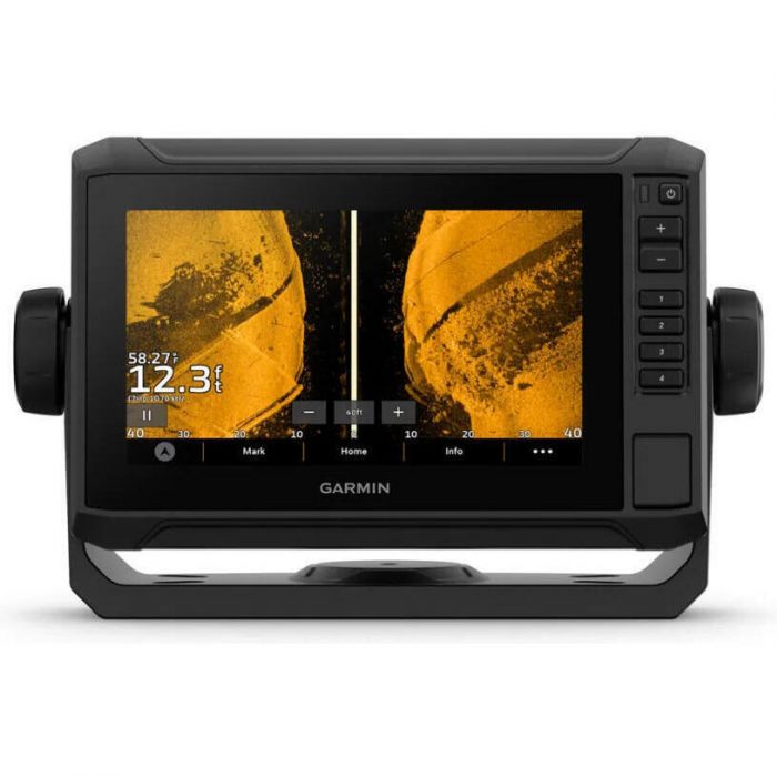
The Garmin ECHOMAP UHD2 73sv Chartplotter delivers unmatched confidence on the water with best-in-class CHIRP sonar, vivid ClearVu and SideVu scanning, and detailed Navionics+ mapping. Its bright 7" touchscreen with keyed assist makes navigation and fishfinding intuitive, while built-in Wi-Fi and multi-band GPS keep you connected and on course.
Garmin ECHOMAP UHD2 73sv Chartplotter Item # 956158
Description
When it comes to catching more fish, they say, "Talk to a local." With the ECHOMAP UHD2 chartplotter, which offers our best-in-class sonar and mapping and premium touchscreen display with keyed-assist, you'll know the water even better than they do.
Features:
- With crisp, clear traditional sonar and brilliant ClearVu and SideVu scanning sonars, the fish will have nowhere to hide
- High-contrast vivid scanning sonar color palettes make it easier than ever to distinguish targets and structure
- You've never seen Garmin cartography like this before. Select chartplotters come with built-in Garmin Navionics+ cartography
- If you have another compatible ECHOMAP UHD2 chartplotter on your boat, you can wirelessly share information — such as sonar1, waypoints and routes — with them
- Built-in Wi-Fi connectivity pairs with the free all-in-one mobile app on your compatible smartphone for access to the OneChart feature, smart notifications, software updates, Garmin Quickdraw Community data and more
- Chartplotters with built-in Garmin Navionics+ charts include downloadable Auto Guidance+ technology with the ActiveCaptain app
- Get improved position accuracy, particularly in areas where signals are reflected or weak, with multi-band GPS
Specifications:
- Dimensions: 8.6" x 5.6" x 3.2" (21.8 x 14.2 x 8.1 cm)
- Input: Touchscreen with Keyed Assist
- Display Size: 6.1" x 3.4", 7.0" (15.5 x 8.7 cm, 17.8 cm)
- Display Resolution: 800 x 480 pixels
- Display Type: WVGA, TN
- Weight: 2.2 lbs (1.0 kg)
- Waterproof: IPX7
- Mounting Options: Bail or flush
- AIS
- DSC
- Supports Fusion-Link Compatible Radios
- Activecaptain Compatible
- Sailing Features
- Maps and Memory:
- Accepts Data Cards: 1 microSD card; 32 GB maximum size
- Waypoints: 5000
- Track Points: 50000
- Tracks: 50 saved tracks
- Navigation Routes: 100
- Sensors:
- Has Built-In Receiver
- Receiver: 10 Hz
- NMEA 2000 Compatible
- GPS
- GLONASS
- Galileo
- Beidou
- Supports WAAS
- Supports Multi-Band, Multi-Constellation GPS
- Sonar:
- Displays Sonar
- Power Output: 500W
- Traditional Sonar (Dual Frequency/Beam): built-in (single channel CHIRP, 50/77/83/200 kHz, L, M, H CHIRP)
- ClearVu: built-in 260/455/800/1000/1200 kHz
- SideVu: built-in 260/455/800/1000/1200 kHz
- Panoptix Sonar
- Livescope
- Connections:
- NMEA 2000 Ports
- Garmin Marine Network Ports: 1
- 12-Pin Transducer Ports: 1
- Bluetooth Pairing
- Ant+ (Connectivity)
- Garmin Wi-Fi Network (Local Connection)
- Electrical Features:
- Power Input: 9 to 18V DC
- Typical Current Draw At 12V DC: 1.52A
- Maximum Current Draw At 12V DC: 3.2A
- Maximum Power Usage At 10V DC: 18.3W
Optional GT54-UHD Transducer Specifications:
- Frequency: CHIRP High Wide (150-240 kHz); UHD ClearVu CHIRP 800 kHz (760-880 kHz); UHD SideVu 1,200kHz (1020-1230 kHz); CHIRP SideVu 455 kHz (425-485 kHz)
- Power: CHIRP Traditional 350 W; ClearV/SideVu 350W
- Beamwidth:
- CHIRP: 24°-16°
- ClearVu: 0.94°x60° @ 800 kHz
- SideVu: 1.62°x50°
- UHD SideVu: 0.441°x52° @ 1200 kHz
- Maximum Depth: CHIRP: 800 ft.; ClearVu 200 ft.; SideVu 500'; UHD SideVu 125'
- Cable Length: 20 ft
- Depth/Speed/Temperature: Depth and Temperature
- Number Of Pins: 12
- Supported Deadrise/Transom Angles: 0°-70° degree transom
Included:
- ECHOMAP UHD2
- GT54-TM transducer (optional, not included with all chartplotters)
- Power cable
- Tilt/swivel mount with quick release cradle
- Protective cover
- Hardware
- Documentation