

Garmin ECHOMAP UHD2 65sv Chartplotter - 010-02682-00
Item: #1376175 | Part Number: 010-02682-00

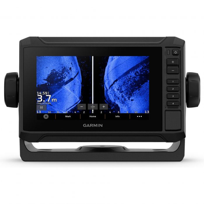
The Garmin ECHOMAP UHD2 65sv Chartplotter delivers best-in-class sonar and mapping in a bright, easy-to-use 6" touchscreen. Featuring traditional, ClearVÜ, SideVÜ, and LiveScope™ sonar support, Navionics®+ charts with Auto Guidance+, and wireless networking, it helps you see more, navigate smarter, and catch more fish.
Garmin ECHOMAP UHD2 65sv Chartplotter - 010-02682-00 Item # 1376175
Description
When it comes to catching more fish, they say, "Talk to a local." With the ECHOMAP UHD2 chartplotter, which offers Garmin's best-in-class sonar and mapping and premium touchscreen display with keyed-assist, you'll know the water even better than they do.
Sonar Support
With crisp, clear traditional sonar and brilliant ClearVü and SideVü scanning sonars, the fish will have nowhere to hide. Your ECHOMAP UHD2 also supports LiveScope live-scanning sonar
Vivid Color Palettes
High-contrast vivid scanning sonar color palettes make it easier than ever to distinguish targets and structure
Preloaded Charts
You've never seen Garmin cartography like this before. Select chartplotters come with built-in Garmin Navionics+ cartography which includes a 1-year subscription for daily updates, depth range shading and more
Wireless Networking
If you have another compatible ECHOMAP UHD2 chartplotter on your boat, you can wirelessly share information such as sonar, waypoints and routes with them
Auto Guidance+ Technology
Chartplotters with built-in Garmin Navionics+ charts include downloadable Auto Guidance+ technology with the ActiveCaptain app
Troll With Force
Your ECHOMAP UHD2 wirelessly connects to your Force trolling motor to create and follow routes, navigate to waypoints, control speed, check battery life and more
Multi-Band GPS
Get improved position accuracy, particularly in areas where signals are reflected or weak, with multi-band GPS
Features:
- The bright 6" touchscreen display with keyed-assist is user-friendly and easy to read
- Good things come in threes. Three sonar types, that is: Garmin traditional, ClearVü and SideVü sonars
- Improved detail? Check. Distinguished targets? Yep. That's the beauty of high-contrast vivid color palettes
- If you're running another ECHOMAP UHD2 chartplotter, you can wirelessly share sonar, waypoints and routes
- Want Garmin's best in mapping? Who doesn't? Select chartplotters come with Garmin Navionics mapping
Specifications:
General
- Dimensions: 5.4" x 3.1", 6.2" (13.8 x 7.8, 15.7 cm)
- Accepts Data Cards: 1 microSD™ card; 32 GB maximum size
- Waypoints: 5,000
- Track Points: 50,000
- Tracks: 50 saved tracks
- Navigation Routes: 100
Sensors
- Has Built-In Receiver: Yes
- Receiver: 10 Hz
- NMEA 2000 Compatible: Yes
- GPS: Yes
- Glonass: Yes
- Galileo: Yes
- Beidou: Yes
- Supports WAAS: Yes
- Supports Multi-Band, Multi-Constellation GPS: Yes
Built-in Maps
- Built-In Auto Guidance: yes
- Garmin Navionics INLAND & COASTAL: yes
- Garmin Navionics (COASTAL): yes
- Garmin Navionics (INLAND): yes
- Tide Tables: yes
- Optional Map Support: Yes
- Garmin Navionics: Yes
- Garmin Navionics Vision+: Yes
- TOPO: Yes
- Standard Mapping: Yes
- Garmin Quickdraw Contours: Yes
Sonar
- AIS: Yes
- DSC: Yes
- Supports Fusion-Link Compatible Radios: Yes
- ActiveCaptain Compatible: Yes
- Sailing Features: Yes
- Displays Sonar: Yes
- Power Output: 500W
- Traditional Sonar (Dual Frequency/Beam): built-in (single channel CHIRP, 50/77/83/200 kHz, L, M, H CHIRP)
- ClearVÜ: built-in 260/455/800/1000/1200 kHz
- SideVÜ: built-in 260/455/800/1000/1200 kHz
- Panoptix Sonar: Yes
- LiveScope: Yes
Connections
- NMEA 2000 Ports: Yes
- Garmin Marine Network Ports: 1
- 12-Pin Transducer Ports: 1
- Bluetooth&Reg Pairing: Yes
- Ant+ (Connectivity): Yes
- Garmin Wi-Fi Network (Local Connection): Yes
Electrical
- Power Input: 9 to 18V DC
- Typical Current Draw at 12V DC: 1.53A
- Maximum Current Draw at 12V DC: 3.2A
- Maximum Power Usage at 10V DC: 18.4W